Tracking Severe Weather Threats and High Heat This Week Across West Michigan
- Jonah Drake (WMIWX Owner & Co-Founder)
- Aug 25, 2024
- 4 min read
Summary:
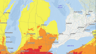
High heat with heat index values over 100°F is likely for at least portions of West Michigan on Monday and is likely for the majority of locations on Tuesday. Heat-related illnesses will be of increased concern due to these high heat index values.
In addition to the high heat, we're also tracking a couple of different days with chances for severe thunderstorms. Each day this week will feature chances for isolated showers and storms at a minimum.
A combination of the more prominent severe weather threat and the hottest forecasted heat index values will make Tuesday the day of most concern for the forecast period.
Dangerous Heat Likely For Several Days:
High heat will be a big focus this week as a heat dome moves into the Great Lakes region bringing very hot temperatures and high humidity into the area sending heat index values soaring into the triple digits.
As mentioned in yesterday's forecast, I would still anticipate that we see Heat Advisories across the area at some point in the next 24 hours and that we will likely see scattered to widespread school closings on Monday and Tuesday, especially for those schools that do not have A/C.
Will defer to making a School Closing Outlook for Monday until later this afternoon/evening. A Day 2 Outlook for Tuesday may be issued as well and will be available to supporters and Patrons later today as well. See options for supporting us and getting exclusive access to those forecasts by clicking the button at the bottom of this forecast.
When we see heat index values over 90°F the threat for heat-related illness becomes a real concern, especially for vulnerable populations (children, the elderly, those who work outdoors, pets, and those with underlying health conditions). Beginning today we will see those heat index values start to exceed that threshold and those values will only continue to increase through Tuesday as temperatures reach the upper 80s to upper 90s across the region and humidity values hover over the 60-70% mark. Make sure to check on these individuals through the middle of this week to ensure their safety and that they are staying cool and well-hydrated. Check with your local community to see if there are cooling shelters available if needed.

Remember, Heat Stroke is a medical emergency! Know the signs and call 911 if you suspect someone is suffering from Heat Stroke!

Severe Weather Potential:
As aforementioned, we're also tracking a couple of different days with severe weather potential.
Today (Sunday) 08/25/2024:
A bit of good news to lead off with; the severe weather risk for today has shrunk a little bit compared to yesterday's outlook.
Still, a level 1/5 (Marginal) risk for severe weather is in place across portions of the far Southeastern part of our coverage area. This risk is driven by a 5-14% risk for both damaging winds and large hail.
Substantial questions remain as to whether or not storms will be able to develop and intensify. Should they develop damaging winds will be the main threat with isolated gusts of 40-60 MPH possible. Some small hail may also be possible, with an extremely isolated threat for a large stone up to 1 inch in diameter. The threat of a tornado is pretty non-existent and we concur with the SPC's assessment at less than 2% in all areas.
The best chances for either of these things will be most favorable with the Southeastern extent generally south of the Metro Detroit area. The remainder of the risk area may still see some severe weather but as storms intensify as they move Southeast those areas will have better chances.
The remainder of our coverage area along and South of a line extending from Traverse City to Sterling Heights remains in a General Thunder risk as some isolated showers and storms may pop up later this afternoon. No severe weather is expected.
Tomorrow (Monday) 08/26/2024:

Continuing the good news; the severe weather risk for Monday that was highlighted in yesterday's Day 3 Outlook from the SPC has been entirely removed from West Michigan in the most recent Day 2 Outlook.
The entire area is under a General Thunderstorm risk again as some showers and storms are possible from mid-afternoon through the overnight hours. Once again, severe weather is not expected with this activity.
One thing of note with this outlook which will play into our next topic of conversation is the large Slight Risk and Enhanced Risk areas that are in place off to our West/Northwest in Wisconsin and Minnesota. These are the risks that will drive our threat for severe storms on Tuesday as that activity shifts off to the East towards Michigan.
Tuesday 08/25/2024:
Tuesday is still of most concern to us as of writing this forecast. The SPC has introduced that level 2/5 (Slight) risk that we mentioned in yesterday's forecast and they now state that while there is still substantial uncertainty, "Wisconsin and Michigan appear to be the centroid of the risk."
Damaging winds and large hail are going to be our threats with this system. Not currently seeing any tornadic concerns but of course this could change come Tuesday so we'll continue to monitor this.
We don't want to speculate much further than that at this point as to timing, storm coverage, mode, or more specific hazards. For now we will continue with our messaging of stay tuned for updates on this severe weather threat!


Comments