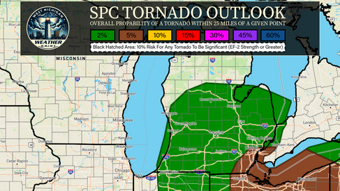
The NWS Storm Prediction Center has placed portions of western and southern lower Michigan under a Slight Risk (Level 2/5) for Severe Weather today.

A broken line of showers and thunderstorms will move through the region late this morning and into the afternoon. Some of these storms will have the potential to be strong to severe as they move through a modestly unstable environment.
Wind profiles are meager at best today and this will preclude the ability for a more intense/widespread severe weather event to occur. Still, a risk for damaging winds, large hail, and perhaps a tornado or two does exist across much of southern lower Michigan today, particularly in the yellow-shaded Slight Risk area from 1:00 PM this afternoon through 8:00 PM this evening.
We're activating storm chase mode, heading south towards south-central Michigan. A livestream may be necessary later today so stay tuned to our social media or our live feed here on our website for updates.

Previous Discussion (Issued at 9:11 AM EDT 04/16/2024):
The SPC has upgraded tomorrow's risk to a Slight Risk (Level 2/5) for severe weather across much of southern and southeastern lower Michigan extending into parts of the West Michigan Weather coverage area. A smaller Marginal Risk delineation surrounds the broader slight risk area.
Current computer weather model guidance suggests a more robust, widespread threat as compared to today's risk. 00z and 06z suites both indicate that a line of showers and storms will move from west to east across the state in the early morning hours from around 5:00 AM to 10:00 AM.
After the morning convection clears out we should have modest to robust clearing across much of the region and the atmosphere should be fairly destabilized as we approach peak heating in the afternoon with some models indicating upwards of 1,500 J/kg to as much as 2,000 J/kg of MUCAPE.
Based on the 06z CAM suites Owen and I would anticipate a westward shift and/or expansion of the Slight Risk delineation with the Day 2 Afternoon SPC Update that comes out around 1:30 PM this afternoon. 06z HRRR, RRFS, MPAS, and to a lesser degree the NAM 3km, suggesting that the most destabilization ahead of the severe convection in the afternoon may occur across west-central into south-central lower Michigan and allow for an increased wind/hail/tornado threat across the western part of the current risk area. This model guidance will continue to be monitored and we'll provide an update(s) this afternoon/evening regarding this 'trend' as the 12z and 18z guidance comes in.
A couple of caveats to tomorrow's threat will be that the primary convective line is expected to come through after a round of morning convection. Depending on timing, this may hamper the afternoon line from intensifying to severe levels. Another limiting factor may be that the primary line of convection, regardless of the morning convection, is currently forecasted to arrive just prior to peak afternoon heating and atmospheric destabilization. Shear, or wind profiles, are also only modest at best with effective 0-3km bulk shear forecasted at as much as 45kts.
Overall, tomorrow is certainly a threat that is worth watching and may prove to pose a decent threat for a couple of isolated tornadoes. Everyone in southern lower Michigan needs to remain #WeatherAware and stay tuned for future forecast updates. Follow us on social media and here on our website for additional information.


Comments