
Severe Weather Chances, Rain & Storms To Close Out The Week
- Jonah Drake (WMIWX Owner & Co-Founder)
- Aug 14, 2024
- 2 min read
Summary:

We'll see one more day of beautiful weather with warm, humid, and sunny conditions across the area today before rain showers and thunderstorms move in, bringing low chances for severe weather and flooding on Thursday and Friday. and largely dominate the forecast for the rest of the work week and weekend.
Thursday 08/15/2024:


Rain and storms will move in on Thursday with a prolonged period of mostly cloudy conditions and showers moving through the region during the day on Thursday.
The environment here in West Michigan and across the Midwest will be supportive of at least some severe weather potential. However, the greatest chances for severe weather will remain off to our South. Locally, severe weather still can't be entirely ruled out in the late afternoon and into the overnight hours but due to the widespread, prolonged rain during the day the environment should be pretty well "worked over" or "used up" and hence, strong to severe storm chances are relatively low.
Prolonged rainfall, possibly heavy at times, across the region, will lead to area-wide low chances for flooding as well but given the lack of recent significant rainfall the concern for flooding is also dropping for Thursday and the greatest risk for flooding has been shifted off to the South.
Friday 08/16/2024:

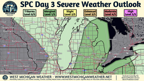


Low severe weather and flooding chances exist on Friday as well although details are highly uncertain and very much dependent on how Thursday's showers and storms perform.
Generally speaking, some showers and thunderstorms should continue to weaken and move across the region Friday morning left over from Thursday night's activity. This may be followed by some clearing in the afternoon and renewed development by late evening. This new development Friday evening may pose some damaging wind or hail threats, but again, it is highly dependent on the degree and duration of atmospheric recovery Friday afternoon.
Some heavy rainfall and low flooding threat will also accompany both rounds of activity on Friday. Similar to Thursday, given the lack of recent rainfall, the flooding risk should remain low but non-zero.
Comments