
Large Hail, Damaging Winds, and Tornado Potential This Evening
- Jonah Drake (WMIWX Owner & Co-Founder)
- Feb 27, 2024
- 1 min read
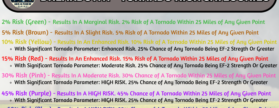
Both Day 1 Outlooks from the SPC have maintained the Slight Risk for much of Lower Michigan. The most recent graphic is below. During the Day 1 Period the SPC updates these graphics a minimum of 5 times. Visit www.spc.noaa.gov for the most recent updates to these outlooks as we may not always update our discussions each time the SPC does so. Also, during the Day 1 Period (the day of the event), the best place to get updated information from us is via social media and via our live stream. Both our available on this website in the menu at the top of the page.


All hazards are in play today including the risk of tornadoes, damaging winds, and large, possibly destructive, hail.
The greatest threat for severe weather will be across the areas of lower Michigan along and south of the I-94 corridor as early as 7:00 PM EST. The severe risk will continue into the overnight hours as cellular storms congeal into lines. As this happens the tornado risk will slowly diminish, with the threat for damaging winds within bowing gust fronts becoming the primary concern.


Be sure to tune into our live stream this evening! We're currently planning to activate storm chase mode and will be targeting southern lower Michigan.

School closures remain possible as well for Wednesday morning. See the end of our post from yesterday evening regarding that threat.
Comments