
A Few More Days Of Flooding & Severe Weather Concerns
- Jonah Drake (WMIWX Owner & Co-Founder)
- Jul 31, 2024
- 2 min read
Summary: Hot, humid weather continues for the remainder of the work week. Chances for heavy rainfall and flooding and low chances for severe weather still exist, at least for today and tomorrow, but overall confidence is very low, especially with regard to the severe weather threat.
Day 1 - Today (Wednesday 07/31/2024):


We will certainly have a moist, unstable airmass in place across the area today but we will likely be lacking any significant forcing mechanism that could spark convection to take advantage of that environment.
Having said that, while most computer weather models keep West Michigan dry today, some guidance suggests that we may see some isolated to widely scattered showers and thunderstorms make it into lower Michigan today.
So while chances are low, they are not zero. The best chance for this activity and any associated heavy rainfall/flooding or strong to severe storm threat will exist primarily along and South of the I-94 corridor.
We'll continue to provide updates surrounding this threat throughout the day today via social media. No plans to storm chase at this time but we will continue to monitor trends.
Day 2 - Tomorrow (Thursday 08/01/2024):


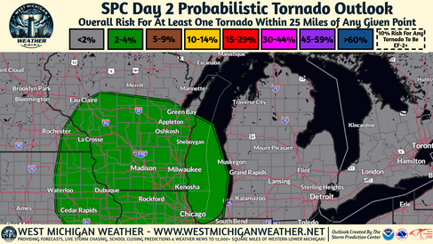


A more appreciable threat for heavy rainfall/flooding and another low chance for a couple of strong to severe storms will exist Thursday evening and into Friday as a better-forcing mechanism to spark shower and storm development moves through the region. With regard to the severe weather threat, it currently looks like the best environment, and therefore the best severe storm chances will remain to the South of the MI/IN/OH border but we can't rule out an isolated strong to severe storm here in lower Michigan especially along and south of the I-96 corridor and West of the US-127 corridor.
Heavy rainfall/flooding is of more concern on Thursday into Friday as compared to the rest of the week so far as the NWS Weather Prediction Center now has a Slight Risk (level 2/4) in place across portions of Berrien, Cass, St. Joseph, Branch, VanBuren, and Kalamazoo Counties indicative of a 15-39% chance for total rainfall amounts or rainfall rates to exceed Flash Flood Warning criteria in these regions. Storms that do form Thursday or that make it into Southwest Michigan will take advantage of the very moist, humid environment and will be prolific heavy rainfall producers with Precipitable Water values over 1 inch and a very slow-moving storm motion.
Day 3 - Friday (08/02/2024):


With regard to the flooding and severe threat on Friday; these threats currently appear to have moved to the South and East of our coverage area and while we will continue to keep an eye on things we don't currently foresee any flooding or severe threats. Thunderstorms will remain possible and warm, humid air will continue to be in place through the day.
Comentarios